

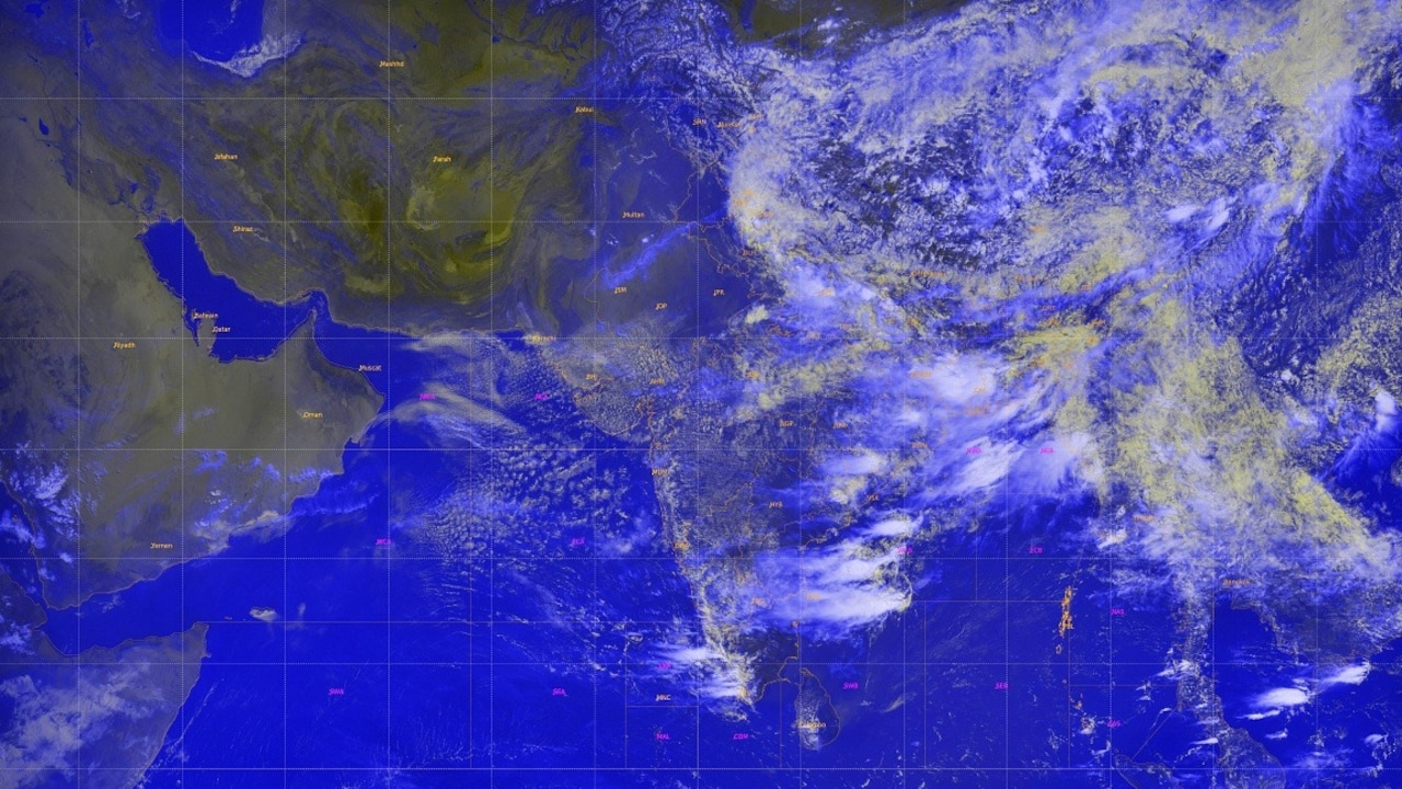
Thermal infrared and water vapor imagery captured between 3:00 PM and 3:27 PM IST on July 22, 2026, shows a continuous cloud band stretching from the Bay of Bengal to the Arabian Sea.
The subcontinental atmospheric channels, satellite remote sensing systems, and regional weather monitoring stations that track India’s climate have registered a massive surge in monsoon activity. Releasing its latest briefing on July 22, 2026, the India Meteorological Department (IMD) confirmed that the southwest monsoon has ended its brief break and returned in full force. High-resolution imagery captured by ISRO’s advanced INSAT-3DS weather satellite shows dense, moisture-laden cloud formations blanketing nearly the entire country.
The sudden increase in cloud density signals a multi-day spell of active rainfall across northern, central, and western India.
Satellite observations reveal a curved cloud band stretching from the northern Bay of Bengal, cutting across Odisha, Chhattisgarh, and Madhya Pradesh, and extending toward Gujarat and the northeast Arabian Sea.
This atmospheric arrangement has prompted the weather office to issue heavy to extremely heavy rainfall alerts for several states.
Also Read | Imran Khan and Bushra Bibi Sentenced to 17 Years in Jail
Decoding the INSAT-3DS Satellite Channels
Understanding how meteorologists read space-based weather data requires looking at how different satellite channels measure cloud properties.
Meteorologists rely on three distinct analytical channels to evaluate incoming storm systems:
-
Thermal Infrared Channel: Measures heat rather than light, allowing forecasters to track cloud structures during both day and night. It clearly outlines the active monsoon trough slicing across central India.
-
Water Vapor Channel: Maps atmospheric moisture levels. Recent readings show a heavily loaded moisture corridor running from the Arabian Sea to the Himalayan foothills, providing the fuel needed for sustained rainfall.
-
Cloud Top Brightness Temperature: Air cools as it rises, so taller clouds have colder tops. Satellite readings show cloud tops over parts of eastern and central India dropping to between -60°C and -80°C. These extreme cold spots mark massive Cumulonimbus clouds punching 12 to 16 kilometers into the atmosphere.
Regional Forecast and Rainfall Warning Matrix
The IMD’s multi-day warning model outlines a sharp contrast between active northern/central belts and subdued southern peninsular regions:
| Targeted Geographic Zone | Expected Monsoon Intensity | Key Affected States / Sub-Divisions | Highest Alert Level & Forecast Dates |
| Western India | Extremely Heavy Rainfall | South Gujarat, Konkan & Goa, Madhya Maharashtra | Red Alert: Isolated extremely heavy downpours (≥21 cm) through July 24. |
| Central India | Heavy to Very Heavy Rainfall | SW Madhya Pradesh, Chhattisgarh, Vidarbha | Orange Alert: Widespread rain with heavy spells through July 26. |
| Northwest India | Isolated Heavy Spells | Jammu & Kashmir, Ladakh, Himachal Pradesh, Uttarakhand | Orange Alert: Enhanced rainfall with school holiday extensions in J&K. |
| East & Northeast | Fairly Widespread Rain | Odisha, Gangetic West Bengal, Assam, Meghalaya | Yellow/Orange Alert: Active thunderstorm activity through July 28. |
| South Peninsular India | Subdued Activity | Tamil Nadu, Rayalaseema, Interior Karnataka | Quiet Phase: Mostly dry conditions over the next 7 days. |
Why the Southwest Monsoon is Essential for India’s Economy
The southwest monsoon is the single most critical weather system for the Indian subcontinent, delivering approximately 75% of the country’s annual rainfall.
Following a dry June that saw national rainfall fall nearly 40% below normal, this mid-July rebound is vital. A strong monsoon recharges reservoirs, supports crop sowing across major agricultural belts, and stabilizes food prices nationwide.
Also Read | Imran Khan and Bushra Bibi Sentenced to 17 Years in Jail
Five Safety Steps to Take During Heavy Monsoon Alerts
To ensure personal safety and protect property during intense rain spells, emergency management authorities recommend following this preparation sequence:
By remaining alert, heeding official warnings, and taking timely precautions, citizens and farming communities can safely navigate this period of intense monsoon activity.
FAQ Section
What do the latest ISRO INSAT-3DS satellite images show about the monsoon?
Images recorded by the INSAT-3DS weather satellite show dense monsoon clouds covering nearly 95% of India. The thermal infrared and water vapor channels highlight a continuous, moisture-rich cloud band running from the Bay of Bengal across central India to the Arabian Sea.
Which regions are under an alert for extremely heavy rainfall?
The IMD has highlighted extremely heavy rainfall risks for southwest Madhya Pradesh, southeast Rajasthan, Konkan & Goa, Madhya Maharashtra, and parts of Gujarat, along with northern regions including Jammu & Kashmir and Ladakh.
Why do colder cloud tops on satellite images indicate heavier rain?
Air cools as it rises into the atmosphere. Colder cloud top temperatures (dropping below -60°C) indicate that storm clouds have grown very tall, forming deep Cumulonimbus clouds capable of producing intense rainfall, lightning, and strong winds.
Also Read | Imran Khan and Bushra Bibi Sentenced to 17 Years in Jail
End….

